
Buckinghamshire Council - New Local Plan consultation - potential site allocations
This consultation has now closed.
On Tuesday 20 February 2026 Buckinghamshire Council launched a consultation, that they are calling a "survey" of sites which they have assessed as suitable for development. As this will affect how Newton Longville is developed over the next 20 years or so, we urge all residents to respond to Buckinghamshire Council.
We gave details of all five sites proposed for allocation by Buckinghamshire Council on pages 18 to 26 of the March/April edition of the Pump. We found issues with the accuracy all five sites and raised this with Buckinghamshire Council. We had partial corrections for two of the sites on Thursday 5 March which are shown below.
Local Plan Sites - next steps
The Parish Council made its decision on its responses to the consultation at the meeting on Monday 16 March 2026. Residents are welcome to attend, but it should be noted that Buckinghamshire Council have set the deadline for responses as 11:59pm that day.
Residents are able to provide feedback on any of the sites proposed to Buckinghamshire Council as well. See below.
The Parish Council submitted survey respones on the five proposed sites within Newton Longville, and three sites outside, one in Stoke Hammond (opposite Newton Leys) and at Whaddon (Shenley Park and Shenley Park 2). The description of the site location/description is given first and then, in brackets, a more accurate location/description.
Sites within Newton Longville
Site: 234 - Land to the north of Stoke Road MK17 0BB - Potential housing capacity 82 (Land to the east of Bletchley Road and north of Stoke Road, bordered by London End, Home Farm and The Slade.)
Site: 298 - Land West of Westbrook End and Lower End, MK17 0DG - Potential housing capacity 112.99 (Land off Drayton Road andto the rear of Westbrook End and Pond Close)
Site: 3383 - Land at Bletchley Leys MK17 0EG - Potential housing capacity 48 (Land immediately to the west of Whaddon Road adjacent to Bletchley Leys Farm, between Weasel Lane and the A421/Bottledump roundabout.)
Site: 4078 - Oaktree stables, Drayton Road, MK17 0BD - Potential 20 Gypsy & Traveller pitches (Land to the west of Drayton Road and south of Cowpasture Farm.)
Site: 6570 - Land to the South West of Milton Keynes, MK17 0BG - Potential housing capacity 181 (The former brickworks site off Bletchley Road plus land on the other side of the public road which was used for the currently unused HGV depot.)
Sites at Stoke Hammond and Whaddon
Site: 680 - Land South of Drayton Road, Newton Leys & Land West of Stoke Road, Newton Leys - Potential housing capacity 2100.74
Site: 3578 - Land west of Shenley Park (SP2) - Potential housing capacity 764.44
Site: 6580 - Shenley Park Shenley Park - Potential housing capacity 1267.2
How to give your feedback to Buckinghamshire Council
All feedback, must be submitted to Buckinghamshire Council by 11:59pm on 16 March 2026.
You will be asked to provide the site location, you should use the details above, including quoting the OPUS reference for the site as shown on each site plan.
All the sites assessed by Buckinghamshire Council for suitability for development can be found on their interactive map. The full map is available from the webpage:
Buckinghamshire Council - Local Plan
Sites included in the potential housing and employment supply are shown in turquoise, and sites requiring further assessment are dark blue.
You may:
• Complete the online survey. Before doing so please read details about each individual sites. You need to comment on each individual site.
• Complete, and return, a printed version of the survey, available from the above link or at one of the parish council drop-ins. Email the form to This email address is being protected from spambots. You need JavaScript enabled to view it. or post it to Local Plan site survey, Planning Policy, Buckinghamshire Council, Walton Street, Aylesbury, HP20 1UA
How to get more information
Anyone with any questions on any of the individual sites or wanting to discuss Buckinghamshire Council’s process can contact them using the details on their Local Plan webpage mentioned above.
The Parish Council may also be able to help so please consider attending the Parish Council drop-in at the Free Church (Bletchley Road, MK17 0AD):
• Monday 9th March 7-9pm
To meet new Government targets, the Buckinghamshire Local Plan (which replaces the Vale of Aylesbury Local Plan or VALP) has to provide for a 43% increase in new homes provision, this increasing to 95,500 dwellings. They also have to provide 681 traveller pitches for Gypsy and Travellers, plus 38 plots for Travelling Showpeople. 500 pitches are needed within the first 10 years of the plan period. In addition, Buckinghamshire’s Employment Land Review has identified an Employment gross requirement of 219 hectares using what they refer to as the Housing Led Scenario. To meet new Government targets, the Buckinghamshire Local Plan (which replaces the Vale of Aylesbury Local Plan or VALP) has to provide for a 43% increase in new homes provision, this increasing to 95,500 dwellings. They also have to provide 681 traveller pitches for Gypsy and Travellers, plus 38 plots for Travelling Showpeople. 500 pitches are needed within the first 10 years of the plan period. In addition, Buckinghamshire’s Employment Land Review has identified an Employment gross requirement of 219 hectares using what they refer to as the Housing Led Scenario. Buckinghamshire has completed five calls for sites since 2021, including two for Brownfield and one for Gypsy and Traveller sites. This produced a list of 1,400 locations which have now been reviewed. On Tuesday 17 February Buckinghamshire Council released an interactive map and a list of sites currently assessed as suitable for development. We appear to have five within our parish boundary, but there is also four large potential sites close to us (A-D in the map below, so two in Stoke Hammond and two in Whaddon parish) which, with potential 4,000+ homes, we could also expect to impact on traffic volumes through the village.
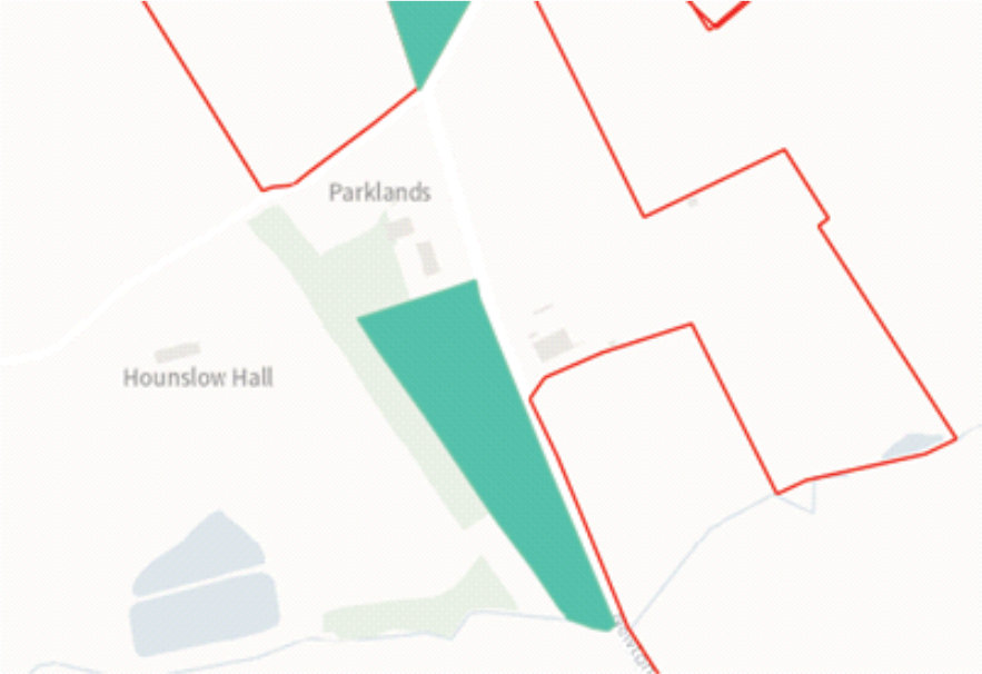
The site maps below are extracted from the Buckinghamshire Council interactive map. The red lines indicate sites promoted for development. Turquoise indicates sites Buckinghamshire Council consider available and suitable for development.
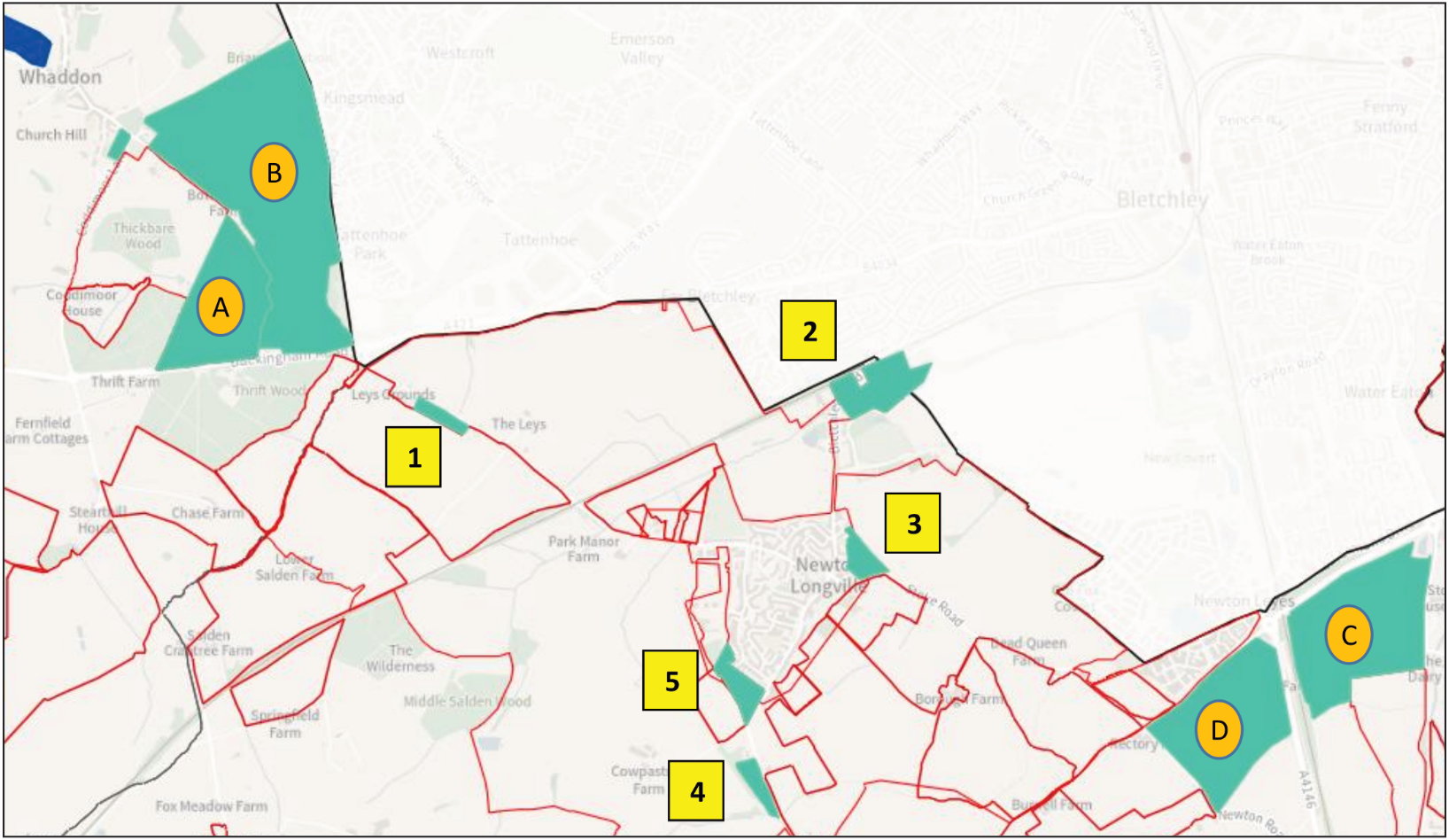
Site 1: WHADDON ROAD
Land immediately to the west of Whaddon Road adjacent to Bletchley Leys Farm, between Weasel Lane and the A421/Bottledump roundabout.
• OPUS reference 3383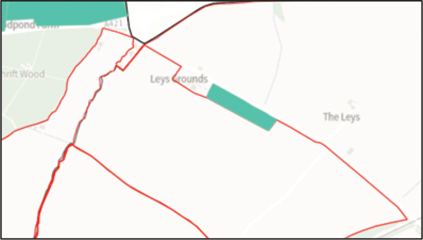
• Land at Bletchley Leys MK17 0EG
• Greenfield
• 2 hectares (ha)
• Potential housing capacity 48
• Density 30
• Policy decision ‘Suitable’
.
Recent site history
- No current planning application or planning approval for housing
- This site was not included in the AECOM 2022 assessment for the Newton Longville Neighbourhood Plan or the HELAA 2017 site assessment
Potential issues include
- Traffic increase through the village and on already overstretched local roads (including A421)
- Road safety on Whaddon Road with hidden dips
- Location has no local public transport service within walking distance
- Impact on already overburdened local services
- Cumulative impact of development on this site along with Salden Place (1,855 dwellings), and other developments in the pipeline and/or proposed for the Buckinghamshire Local Plan inside or in close proximity to the Newton Longville parish boundary. To that list should be added the proposed East West Rail train maintenance depot (TMD) off Whaddon Road, the solar farm off Bletchley Road and the gas injection facility which is also off Bletchley Road.
Site 2: BLETCHLEY ROAD – Updated 4 March 2026
Land to the north of Stoke Road [Land to the east of Bletchley Road and north of Stoke Road, bordered by London End, Home Farm and The Slade.]
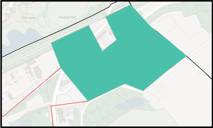 OPUS reference 6570
- Land to the South West of Milton Keynes, MK17 0BG
- Mixed site type (brownfield/greenfield)
- 7.57 hectares
- Potential housing capacity 181
- Density 30
- Policy decision ‘Part suitable’
Recent site history
- The brickworks site has current planning approval for open storage and the erection of four modular buildings for ancillary office use (13/02051/APP)
- The site was used 2020-2023 by the East West Rail Alliance for their Compound B6.
- AECOM 2022 assessment for the Newton Longville Neighbourhood Plan (part sites 8 and 24) was that this area of the parish was not suitable with the statements “Development on the site would also cause coalescence between Bletchley and Newton Longville…” and “Residential development will result in a sporadic form of development which does not relate to existing communities and the built up area of Newton Longville and Bletchley”.
- The HELAA 2017 assessment (site NLV029) was that the location was Unsuitable “…The site in considering new buildings is more prominent in the wider landscape than part of the site NLV009 adjacent the railway line. A development on the site (presently open land, previous buildings demolished) would also be likely to have an adverse landscape and visual impact
Potential issues include
- The map indicates that the site straddles both sides of Bletchley Road to include the HGV depot and extends at its eastern end over the border with Milton Keynes
- Traffic increase through the village and on already overstretched local roads (including A421)
- Ecology
- Impact on already overburdened local services.
- Part of the proposed site allocation is prone to flooding.
- Cumulative impact of development on this site along with Salden Place (1,855 dwellings), and other developments in the pipeline and/or proposed for the Buckinghamshire Local Plan inside or in close proximity to the Newton Longville parish boundary. To that list should be added the proposed East West Rail train maintenance depot (TMD) off Whaddon Road, the solar farm off Bletchley Road.
Site 3: BLETCHLEY/STOKE ROADS – Updated 4 March 2026
Land to the north of Stoke Road [Land to the east of Bletchley Road and north of Stoke Road, bordered by London End, Home Farm and The Slade.]
- OPUS reference 234
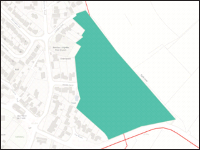
- Land to the north of Stoke Road MK17 0BB
- Mixed site type (brownfield/greenfield)
- 2.42 hectares
- Potential housing capacity 82
- Density 30
- Policy decision ‘Part suitable’
Recent site history
- No current planning application or planning approval for housing
- The AECOM 2022 assessment for the Newton Longville Neighbourhood Plan (a slightly larger site 7) was that the site is unsuitable, stating “…development would appear as an insensitive minor intrusion into open countryside and would not relate well to the village.”
- The HELAA 2017 assessment was for a larger site including the area shown (site NLV008) was “Part Suitable” but it was not then allocated into the Vale of Aylesbury Local Plan
Potential issues include
- Site is on the immediate outside edge of the village Settlement Boundary
- Settlement creep towards neighbouring Newton Leys
- Impact on already overburdened local services
- Traffic increase through the village and on already overstretched local roads (including A421)
- High pressure gas main running diagonally from the vicinity of Home Farm to Stoke Road
- Two public footpaths cross the site
- Land is part historic ridge and furrow (source Buckinghamshire Heritage Portal)
- Ecology, including this being the local habitat for a number of rare species (source Buckinghamshire and Milton Keynes Environmental Records Centre) and the location of three seasonal ponds
- Setting for adjacent/nearby Heritage listed properties (including Grade I St Faith church) and the Newton Longville Conservation Area.
- Cumulative impact of development on this site along with Salden Place (1,855 dwellings), and other developments in the pipeline and/or proposed for the Buckinghamshire Local Plan inside or in close proximity to the Newton Longville parish boundary. To that list should be added the proposed East West Rail train maintenance depot (TMD) off Whaddon Road, the solar farm off Bletchley Road and the gas injection facility which is also off Bletchley Road.
Site 4: DRAYTON ROAD
Land to the west of Drayton Road and south of Cowpasture Farm
- OPUS reference 4078
- Oaktree stables, Drayton road, MK17 0BD
- Mixed site type (brownfield/greenfield)
- 2.65 hectares
- Potential 20 Gypsy & Traveller pitches
- Policy decision ‘Suitable’
Recent site history
- Current planning application ‘Awaiting decision’ for change of use of land to a mixed use of equestrian, a single pitch travellers caravan site including the relocation and internal modification of the approved stable block (24/01046/APP) as a stable and utility dayroom and associated works
- This site was not assessed either in the AECOM 2022 assessment for the Newton Longville Neighbourhood Plan or for the earlier HELAA 2017 assessment. However, the assessment of a nearby site (NLV010) was “Unsuitable - The site if approved for a potential allocation would be an isolated pocket of development protruding significantly into the open countryside not related in any way to the existing village of Newton Longville and relatively remote from its services…”
Potential issues include
- Location would represent residential development outside the village Settlement Boundary
- This is not a sustainable location (for example there is no footway to give safe access to local transport services operating from the village)
- Impact on already overburdened local public services
- Cumulative impact of development on this site along with Salden Place (1,855 dwellings), and other developments in the pipeline and/or proposed for the Buckinghamshire Local Plan inside or in close proximity to the Newton Longville parish boundary. To that list should be added the proposed East West Rail train maintenance depot (TMD) off Whaddon Road, the solar farm off Bletchley Road and the gas injection facility which is also off Bletchley Road.
Site 5: DRAYTON ROAD/POND CLOSE/WESTBROOK END
An extended site compared to the current (Gladman) planning application on the corner of Drayton Road and Westbrook End, incorporating additional land.
- Opus reference 298
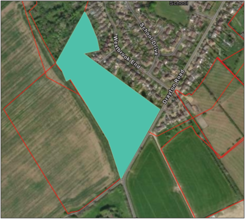
- Land West of Westbrook End and Lower End, MK17 0DG
- Greenfield
- 4.71 hectares
- Potential housing capacity 112.99
- Policy decision ‘Part suitable’
Recent site history
- (Gladman) planning application 24/01220/AOP on part of the site nearest to Drayton Road. (Outline planning application with all matters reserved except for means of access for the erection of up to 50 dwellings, with public open space, landscaping, sustainable drainage system (SuDS) and vehicular access point). See also page 28.
- Previous application for a 58 house development on the same site, 19/01754/AOP, rejected 2020.
- AECOM 2022 assessment for the Newton Longville Neighbourhood Plan (sites 2A, 2B & 2C) states was not suitable for allocation in the NP, apart from potentially one dwelling on a small area near to Pond Close.
- The HELAA 2017 assessment (for site NLV002) was “Unsuitable - The site is in the open countryside and very exposed to the south. There is no corresponding development to the east development of this site would represent a prominent protrusion into the open countryside.”
Potential issues include
- Site is on the immediate outside edge of the village Settlement Boundary
- Settlement creep towards neighbouring Drayton Parslow and Mursley
- Traffic increase through the village and on already overstretched local roads (including A421)
- Drainage/flooding issue
- Land is part historic ridge and furrow (source Buckinghamshire Heritage Portal)
- Ecology, including this being the local habitat for a number of rare species (source Buckinghamshire and Milton Keynes Environmental Records Centre)
- Impact on already overburdened local services
- Cumulative impact of development on this site along with Salden Place (1,855 dwellings), and other developments in the pipeline and/or proposed for the Buckinghamshire Local Plan inside or in close proximity to the Newton Longville parish boundary. To that list should be added the proposed East West Rail train maintenance depot (TMD) off Whaddon Road, the solar farm off Bletchley Road and the gas injection facility which is also off Bletchley Road.